metadata.catalog.inspire-geoportal.lt
Annex II. INSPIRE Dataset for Geology Theme - Hydrogeology
INSPIRE dataset for Geology theme represents geological information for the territory of Lithuania.
Layer with Active well objects is not public, in order to get data you need to contact the Lithuanian geological survey which is the resource provider, lgt@lgt.lt .
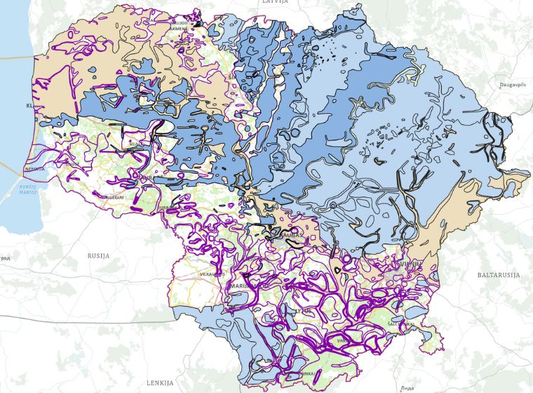
Layers GE.AquiferSystems, GE.Aquiclude, GE.Aquifer, and GE.Aquitard are shown at a scale of 200 000:100 000 000.
Simple
- Date (Publication)
- 2020-06-22
- Date (Revision)
- 2023-08-30
- Citation identifier
- LT.LGT.GEHG / GE.HG
- Citation identifier
- LT.LGT.GEHG / GE.ActiveWell
- Citation identifier
- LT.LGT.GEHG / GE.Aquiclude
- Citation identifier
- LT.LGT.GEHG / GE.Aquifer
- Citation identifier
- LT.LGT.GEHG / GE.AquiferSystems
- Citation identifier
- LT.LGT.GEHG / GE.Aquitard
- Citation identifier
- LT.LGT.GEHG / GE.GroundWaterbody
- Citation identifier
- de12a7ef-86af-45e4-af13-c1588211d228
- Point of contact
-
Organisation name Individual name Electronic mail address Role Construction Sector Development Agency
Custodian Lithuanian geological survey
Resource provider
- Maintenance and update frequency
- As needed
- Keywords
- Keywords
- Use constraints
- Other restrictions
- Other constraints
- general conditions for the use
- Other constraints
-
© intellectual property rights
- Use limitation
-
Not for commercial use
- Access constraints
- Other restrictions
- Other constraints
- no limitations to public access
- Spatial representation type
- Vector
- Denominator
- 10000
- Language
- English
- Topic category
-
- Geoscientific information
))
- Unique resource identifier
- EPSG:4258
- Distribution format
-
Name Version GML
3.2.1
- Distributor contact
-
Organisation name Individual name Electronic mail address Role Construction Sector Development Agency
- OnLine resource
- Hierarchy level
- Dataset
Conformance result
- Date (Publication)
- 2010-12-08
- Explanation
-
This data set is conformant with the INSPIRE Implementing Rules for the interoperability of spatial data sets and services
- Pass
- Yes
- Statement
-
INSPIRE dataset for Geology theme is created using input data sets provided by Lithuanian Geological Survey: 1) neotectonically active faults, 2) borings, 3) hydrogeological borings, 4) groundwater bodies, 5) hydrogeological objects, 6) underground water monitoring facilities and borings, 7) seismic monitoring stations, 8) Lithuanian Quaternary geological map M 1:200 000, 9) Lithuanian geomorphological map M 1:200 000, 10) Lithuanian Pre-Quaternary geological map M 1:200 000, 11) Hydrogeological map M 1:200 000.
The output data set is created by Construction Sector Development Agency, Lithuania.
Metadata
- File identifier
- de12a7ef-86af-45e4-af13-c1588211d228 XML
- Metadata language
- English
- Character set
- UTF8
- Hierarchy level
- Dataset
- Date stamp
- 2026-04-15T12:52:44.012Z
- Metadata author
-
Organisation name Individual name Electronic mail address Role Construction Sector Development Agency
Point of contact